
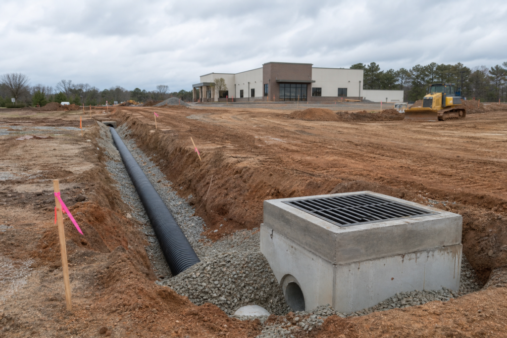
The right stormwater drainage solution for a Bethlehem project cannot be selected from a preferred pipe, pond, or inlet alone. The decision depends on grading, soil conditions, available space, downstream conditions, maintenance responsibilities, construction access, and the review requirements that apply to the project.
This article focuses on commercial developments, residential subdivisions, roadway work, and public infrastructure. It explains planning mistakes that can create scope gaps or redesign risk, then gives you a practical way to compare stormwater approaches and prepare for a contractor or engineering discussion.
Key Takeaways
- Coordinate stormwater with grading, pavement, utilities, access, erosion control, and existing drainage features.
- Review soils, groundwater, slopes, footprint, receiving waters, and discharge points before favoring conveyance, retention, or infiltration.
- Clarify who will inspect and maintain the system after construction, including any pond, pipe, inlet, or treatment feature.
- Separate professional design and agency approval from construction, field layout, documentation, and closeout support.
- Provide plans, surveys, existing-condition information, requested scope, and deliverables when asking for a quote.
Stormwater planning mistakes that create project risk
Stormwater work is part of the site’s larger civil system. A drainage decision can affect finished grades, pavement elevations, slopes, utilities, adjacent properties, roadway access, construction staging, and long-term maintenance.
Before comparing contractors or pipe materials, ask whether the project team has enough site information to compare solutions fairly. The following concerns are useful checkpoints before design is finalized or a construction scope is priced.
1. Treating drainage as separate from grading and site layout

Drainage follows the site’s elevations and flow paths, so it should not be left until after earthwork or paving decisions are complete. Finished floor elevations, roadway grades, parking areas, swales, ditches, structures, utilities, inlets, and pipe crossings must work together rather than compete for space.
Changing a roadway edge or access point can alter runoff toward an existing ditch, culvert, neighboring property, or downstream structure. The project team should review topography, pavement edges, slopes, utilities, property lines, and existing drainage before finalizing layout. For broader planning around grading, utilities, permitting, and drainage, see civil site work in Bethlehem.
Ask where water will travel during ordinary storms and where it will go during a larger event if the primary system is full. The answer should be coordinated with the approved plans and the appropriate design professional or reviewing authority.
2. Choosing a system before confirming site constraints
Conveyance, retention, and infiltration are not interchangeable features. Each responds differently to soil, groundwater, available footprint, slopes, discharge points, receiving waters, maintenance capacity, construction access, and water-quality expectations.
Infiltration may require suitable soils and adequate separation from groundwater or other constraints. Retention or detention features require usable space, safe access, an appropriate outlet, and a maintenance plan. Conveyance systems may move runoff efficiently, but they still need coordinated inlets, pipes, slopes, outlets, and downstream capacity.
Property owners comparing drainage options can use this storm water systems guide to evaluate site constraints, maintenance needs, retention, infiltration, and conveyance.
Do not treat a named feature as a complete solution. A pipe type, pond, inlet, or infiltration area may be one component of a larger system, but final selection requires project-specific engineering, site information, and review of applicable requirements.
Stormwater approach comparison for early planning
The table below supports early discussions, not final system selection. It helps project teams identify questions to resolve with the engineer, contractor, owner, municipality, or DOT team.
| Approach | Primary function | Conditions to investigate | Questions to resolve |
|---|---|---|---|
| Conveyance | Collect and move runoff through inlets, pipes, channels, or crossings. | Grades, pipe alignment, inlet locations, outlet conditions, downstream capacity, utilities, and access. | Where does the water discharge, and what happens if the downstream system is constrained? |
| Retention or detention | Temporarily store or manage runoff in a basin or related feature. | Available footprint, slopes, outlet configuration, groundwater, receiving waters, safety, and maintenance access. | Who will inspect, mow, remove sediment, and maintain the outlet or associated structures? |
| Infiltration | Allow suitable runoff to enter the soil rather than relying only on surface discharge. | Soil infiltration rate, groundwater depth, pretreatment, contamination concerns, slope, and long-term performance. | Does the site support infiltration, and what maintenance is needed to prevent clogging? |
3. Ignoring downstream conditions and construction-phase erosion
A drainage improvement on one parcel can change the flow reaching a ditch, pipe, culvert, slope, wet area, or neighboring property. Review both the proposed discharge point and the path water will take after it leaves the project area. Existing conditions may include drop inlets, catch basins, manholes, slope drains, roadway crossings, flumes, or spillways.
Permanent drainage also needs to be coordinated with temporary erosion and sediment controls during construction. Depending on approved plans and site conditions, measures may include silt fence, inlet protection, seeding and mulching, check dams, and erosion matting. Permanent drainage is not a substitute for construction-phase controls, and temporary controls are not a substitute for permanent drainage planning.
For roadway or access work, ask how grading, drainage, pavement transitions, traffic staging, and erosion control will be sequenced. Review existing ditches, pipes, culverts, slopes, downstream conditions, and adjacent properties before construction decisions are made.
4. Leaving maintenance ownership unclear
A system that works at turnover still needs an owner and a maintenance routine. Before choosing an approach, identify who will inspect inlets, clear debris, mow or maintain a basin, remove sediment, repair erosion, check outlets, and address damaged pipes or structures.
Maintenance capacity should influence the comparison from the beginning. A feature that requires regular access, sediment removal, filter-media replacement, vegetation management, or inspection may not be practical if no responsible party, budget, access route, or schedule has been established.
Put expected maintenance responsibilities into the project documentation. Ask what records will be provided at closeout, what conditions should trigger corrective work, and whether the owner or a public agency has a required inspection process.
5. Overlooking review requirements and closeout documentation
Commercial, subdivision, roadway, municipal, and Georgia DOT-related projects can have different design, review, inspection, and documentation expectations. Identify the applicable pathway early rather than assuming that a construction quote includes professional design, permitting, or agency approval.
Construction support may include installation, erosion control, field layout, grade calculations, quantity verification, estimating, takeoff, or as-built documentation. DCBC LLC lists construction stakeout plans, roadway grade calculations, three-point level verification, estimation and takeoff, and GDOT as-built GIS submittals among its virtual and consulting capabilities. These services support project delivery, but they do not make the contractor the permitting authority or replace the responsibilities of the project engineer or reviewing agency.
Ask bidders to identify exactly what they are pricing. Useful distinctions include design versus construction, survey information versus field verification, installation versus inspection, and as-built preparation versus agency acceptance.
6. Requesting a quote without enough project information
An incomplete request often produces an incomplete comparison. A contractor needs enough information to understand the site, requested scope, constraints, and deliverables before preparing a meaningful quote.
Bethlehem project information checklist
- Project location, parcel information, and a description of the proposed development or improvement.
- Project type, such as commercial development, residential subdivision, roadway improvement, or public infrastructure.
- Available civil, drainage, roadway, utility, grading, and erosion-control plans.
- Boundary and topographic survey information, including relevant elevations and property lines.
- Existing ditches, inlets, pipes, culverts, pavement, slopes, utilities, structures, and known drainage complaints.
- Available geotechnical or soil information, including known groundwater or infiltration constraints.
- Proposed discharge points, receiving waters, adjacent properties, and downstream concerns.
- Known municipality, MS4, engineer, surveyor, owner, or Georgia DOT involvement.
- Requested work, such as stormwater installation, earthwork and grading, erosion control, paving, roadway crossings, or related site work.
- Requested deliverables, such as stakeout plans, grade calculations, estimation and takeoff, verification measurements, or as-built GIS documentation.
- Construction access, staging limitations, traffic requirements, schedule constraints, and phasing assumptions.
If some information is unavailable, say so clearly. An early discussion can identify missing surveys, soil information, design details, or approvals before the work is priced as if those items were resolved.
Questions to resolve before selecting a stormwater approach
- What problem is the system intended to address, and what performance or water-quality requirement applies?
- Where does runoff originate, where should it go, and what downstream conditions could limit that path?
- How do proposed grades, pavement, utilities, structures, and access routes affect the drainage layout?
- Do soil conditions, groundwater, slopes, or available footprint limit infiltration or storage?
- What temporary erosion-control measures are needed while the permanent system is being built?
- Who is responsible for inspection, maintenance, sediment removal, vegetation management, and repairs?
- Which party is responsible for professional design, permitting, agency coordination, construction, and closeout documentation?
- What field measurements, grade checks, as-built records, or GIS deliverables are required?
How to structure the Bethlehem project discussion
Bring the owner, design team, reviewing authority, and contractor into the discussion at the right points. The engineer or other qualified design professional should address project-specific design decisions and applicable approvals. The contractor can then confirm constructability, scope, sequencing, materials, field layout, quantities, erosion-control work, and documentation support.
For a project that combines stormwater with roadway or site work, request a coordinated scope rather than separate disconnected prices. DCBC LLC’s verified capabilities include stormwater systems, earthwork and grading, erosion control, asphalt paving and milling, roadway improvements, construction stakeout plans, grade calculations, estimation and takeoff, and GDOT as-built GIS submittals. The company presents both turnkey and specialized construction and consulting support, subject to the project’s plans and requirements.
Frequently asked questions
Can a stormwater drainage solution be selected from the pipe type alone?
No. HDPE, reinforced concrete pipe, ductile iron pipe, or another material is only one part of the system. Alignment, slope, inlets, outlets, soil, groundwater, loading, access, downstream conditions, maintenance, and applicable requirements all affect the appropriate design.
What information should a Bethlehem project team provide before requesting a stormwater quote?
Provide the location, project type, available plans, survey and topographic data, existing drainage and utilities, soil information, proposed grades, roadway context, known agency involvement, requested scope, required deliverables, access limitations, and schedule assumptions. If information is missing, identify it rather than leaving the contractor to infer it.
Who is responsible for stormwater system maintenance after construction?
The responsible party depends on the project structure, ownership, approved documents, and applicable authority requirements. Establish the owner or maintenance entity before construction and document inspection, mowing, sediment removal, outlet care, vegetation management, and repair responsibilities.
When should drainage planning be coordinated with erosion control and roadway work?
Coordination should begin during early site and roadway planning, before grading, pavement transitions, and construction staging are finalized. Drainage changes can affect slopes, ditches, culverts, adjacent properties, and temporary erosion controls.
What documentation may be needed for a Georgia DOT-related stormwater project?
Requirements depend on the project and reviewing authority. Possible needs include approved plans, field layout, grade verification, inspection records, quantity information, and as-built documentation. Confirm required deliverables with the project engineer and applicable agency before requesting construction support.
Conclusion: Compare the site before comparing the system
The most reliable starting point for stormwater drainage solutions in Bethlehem is not a preferred feature or pipe material. Start with site data, grading, soils, groundwater, available footprint, downstream conditions, receiving waters, maintenance ownership, construction access, and the review pathway that applies to the project.
Then turn those findings into a coordinated scope covering drainage, erosion control, earthwork, roadway or pavement work, field verification, and closeout documentation. This gives engineers, owners, public agencies, and contractors a clearer basis for comparing options and identifying unresolved decisions before construction.
For stormwater systems, grading, erosion control, roadway work, field layout, estimating, or related documentation support in Georgia, request a project-specific discussion with DCBC LLC. Share the available plans, site information, requested scope, and deliverables so the team can determine whether a turnkey or specialized scope is appropriate.