
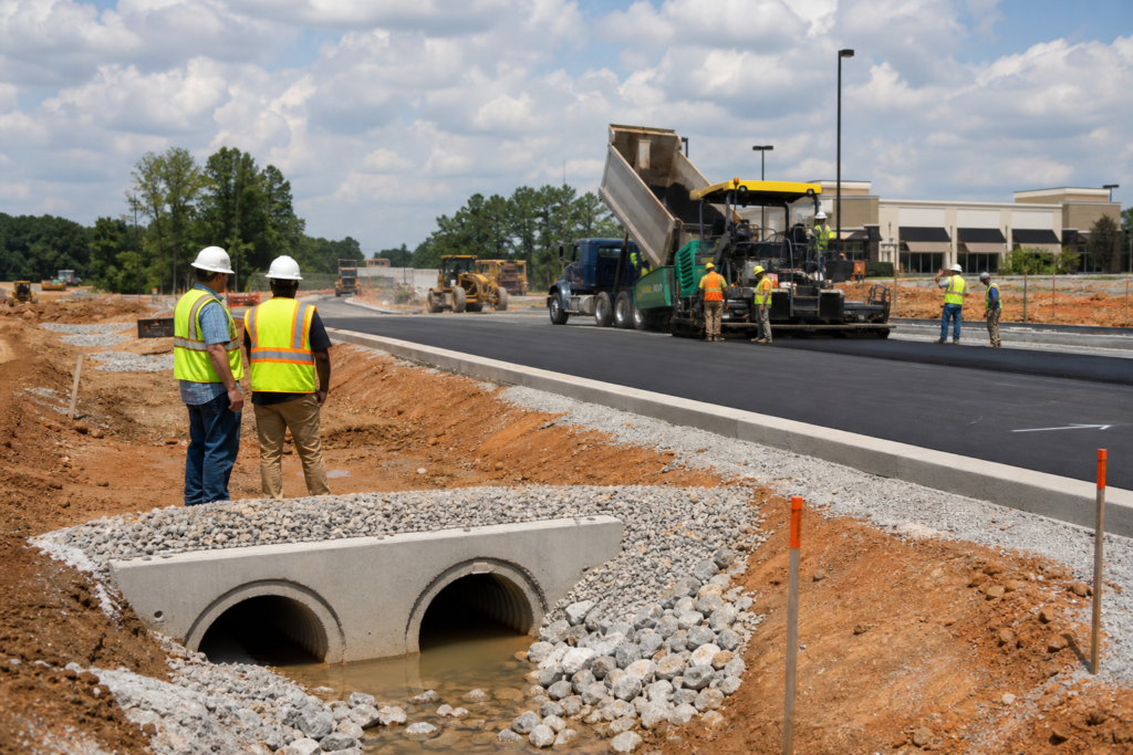
Roadway construction planning is the coordinated preparation that connects a project’s purpose, existing conditions, engineering and survey information, construction scope, quantities, responsibilities, staging, and closeout requirements. It applies to subdivision streets, access roads, turn lanes, roadway improvements, and related civil site work.
It is more than deciding where asphalt will be placed. Effective planning brings grading, stormwater drainage, earthwork, pavement, access geometry, markings, signage, erosion control, documentation, and agency responsibilities into one workable scope before bidding or mobilization.
Key Takeaways
- Roadway construction planning integrates project objectives with practical execution elements.
- Effective planning clarifies responsibilities and ensures compliance with local regulations.
- Choosing the right delivery scope is crucial for accurate bid comparisons.
- Early coordination of grades, drainage, and earthwork can prevent costly delays.
- A comprehensive checklist can streamline the planning process and ensure all aspects are covered.
What roadway construction planning includes
Roadway construction planning is the coordination layer between an approved project objective and the work required to build, improve, or document the roadway. It answers practical questions such as what is being built, where the limits are, how it will connect to existing conditions, which quantities must be priced, and who is responsible for each decision.
The process may cover access drives, subdivision roads, commercial entrances, turn lanes, acceleration or deceleration lanes, roadway reconstruction, parking connections, and public infrastructure. For a Georgia project, the planning conversation may also need to address applicable municipality or Georgia DOT requirements, depending on the roadway and project responsibilities.
Planning is related to roadway design, but it is not the same thing. Design professionals establish design intent and technical requirements. Surveyors establish or verify survey information and control. Contractors execute the defined construction scope. Owners, municipalities, and agencies make decisions or approvals within their authority. A good plan makes those boundaries visible rather than leaving them to be resolved during construction.
Choose the right delivery scope before requesting bids

The first commercial decision is whether the project needs a complete civil package, a defined roadway or drainage scope, or specific planning and documentation support. Each option can be appropriate, but the handoffs and risks differ.
| Delivery approach | What it may include | What to clarify |
|---|---|---|
| Turnkey civil package | Earthwork and grading, stormwater systems, paving, erosion control, markings, signage, and project coordination. | Exact limits, exclusions, design responsibility, subcontractor interfaces, inspections, and closeout deliverables. |
| Defined roadway scope | A focused package such as milling and asphalt paving, a turn lane, drainage improvements, or roadway striping. | Existing-condition assumptions, tie-ins, access during work, quantities, and responsibility for adjacent work. |
| Technical or virtual support | Stakeout plans, roadway grade calculations, three-point verification, estimating and takeoff, or GIS documentation. | Source information, required format, field responsibilities, professional review, and how the deliverable will be used. |
Do not compare proposals until the scope model is clear. A quote for asphalt paving alone is not directly comparable with a proposal that includes grading, stormwater drainage, erosion control, striping, traffic signs, and project management.
Coordinate grades, drainage, and earthwork early
Roadway grades affect more than the finished pavement. They influence tie-ins, drainage flow, earthwork quantities, pavement preparation, access geometry, and the relationship between the roadway and surrounding lots or improvements. Drainage structures such as pipes, drop inlets, catch basins, manholes, slope drains, and outlets must be considered alongside the proposed grades.
Before relying on a grade calculation, confirm the project objective, datum, benchmarks, alignment, stationing, elevations, distances, source documents, and tie-in conditions. Field verification is important where existing conditions may differ from the available plans or survey. These are the core roadway grade calculation methods that help teams understand what a calculation can and cannot establish.
A calculation or field check does not automatically prove drainage performance, constructability, safety, or agency compliance. When design intent, survey control, sealed documents, or approval requirements are unclear, assign review to the appropriately qualified professional before earthwork or paving proceeds.
Define pavement, access, and roadway features
Roadway construction planning should identify how the pavement will be prepared, placed, connected, and finished. Depending on the project, the scope may include earthwork and grading, subgrade preparation, asphalt paving, asphalt milling, pavement removal, new pavement transitions, or repairs at existing tie-ins.
Access improvements require their own coordination. A turn lane or widened entrance may involve excavation, fill, shoulders, slope adjustments, drainage changes, pavement transitions, striping, and traffic signs. Review the vehicle movements the access must serve, including passenger vehicles, delivery trucks, construction traffic, and emergency access where relevant.
Markings and signs should not be treated as an afterthought. Define parking stalls, crosswalks, accessible markings and signs, lane markings, highway signs, wheel stops, and other traffic-control features in the scope when they are part of the project. Final geometry, marking requirements, and agency decisions remain project-specific.
Assign responsibilities across the project team
Roadway planning works best when every major decision has an identified owner. The following division is a starting point, not a substitute for the project contract or applicable requirements.
| Participant | Planning responsibility to clarify |
|---|---|
| Owner or developer | Project purpose, budget priorities, access needs, property information, decisions, and required deliverables. |
| Engineer or designer | Design intent, technical criteria, plans, specifications, design revisions, and professional review within the agreed scope. |
| Surveyor | Survey control, existing-condition information, benchmarks, boundaries, and survey-related verification. |
| Contractor | Construction means and methods, execution of the contracted work, field coordination, quantities within the agreed scope, and construction records. |
| Municipality or agency | Applicable review, approvals, inspections, access or traffic requirements, and agency-specific documentation within its authority. |
| Project manager | Handoffs, schedule coordination, change communication, meetings, records, and responsibility tracking. |
Before finalizing the plan, use a roadway construction compliance checklist to assign grading, drainage, paving, erosion control, field verification, and closeout responsibilities. The checklist should support project coordination, not promise inspection or permit approval.
Build quantities, assumptions, and a workable budget
A roadway estimate should be traceable to the plans and the assumptions behind them. A construction estimating takeoff connects plan quantities with materials, labor, earthwork assumptions, asphalt lift calculations, and procurement decisions.
At a minimum, organize the estimate by measurable scope. Useful categories may include clearing or removal, cut and fill, aggregate base, asphalt lifts, milling, drainage pipe and structures, curb or edge treatments, erosion-control measures, striping, signage, and restoration. Record units, quantities, waste or allowance assumptions, supplier minimums, and items that remain unresolved.
Use the same scope breakdown when comparing bids. Identify exclusions such as design, survey, utility relocation, traffic control, permits, testing, inspections, or as-built documentation rather than assuming they are included. This makes it easier to distinguish a lower price from a narrower scope.
Plan erosion control, staging, and closeout
Stormwater and erosion control belong in the initial plan because construction changes site surfaces, grades, drainage paths, and access conditions. Depending on the project, the scope may include stormwater systems, inlet protection, silt fence, check dams, seeding and mulching, erosion matting, slope drains, or other measures.
Also plan how vehicles, deliveries, residents, customers, and emergency users will move through or around the work area. Sequencing may affect when grading, drainage, pavement, striping, and erosion-control measures are installed. For public work, traffic restrictions and staging may require coordination among the agency, contractor, and local officials.
Closeout should be defined before construction starts. Identify required inspection records, quantity records, field changes, photographs, testing information, warranties if applicable, and as-built deliverables. GIS mapping for civil projects can organize roadway limits, drainage features, grading information, field records, and closeout documentation, but it does not replace surveying, engineering, construction staking, or agency review.
Where stakeout, grade verification, and GIS support fit
Technical planning services can help connect approved information to field execution. Construction stakeout plans may organize locations for roadway, site, utility, or structure work. Roadway grade calculations may address a defined elevation or slope question. Three-point level verification may support a specific field check, and estimation and takeoff can help convert plans into quantities.
These services have limits. A stakeout plan does not replace a survey. A grade calculation does not replace roadway design. A GIS record does not establish construction accuracy. Assign professional surveying, engineering, sealed documents, inspections, and agency approvals to the appropriate parties.
DCBC LLC is a Georgia-based civil site work and roadway construction contractor with Georgia DOT certification. Its listed capabilities include asphalt paving and milling, earthwork and grading, stormwater systems, erosion control, turn lanes, striping, signage, construction stakeout plans, roadway grade calculations, three-point level verification, estimation and takeoff, and GDOT as-built GIS submittals.
Roadway construction planning checklist
- Project location, purpose, roadway limits, property constraints, and expected vehicle movements.
- Available civil plans, roadway plans, surveys, topography, benchmarks, property information, and existing-condition records.
- Existing pavement, drainage features, utilities, driveways, signs, slopes, and tie-in conditions.
- Required access improvements, turn lanes, acceleration or deceleration lanes, pavement transitions, markings, and signage.
- Defined grading, stormwater, erosion-control, paving, milling, and restoration scope.
- Grade calculation, stakeout, three-point verification, takeoff, GIS, or as-built deliverables.
- Responsibility for design, survey control, construction, inspections, field changes, approvals, and closeout.
- Construction access, traffic control, staging, sequencing, working-hour constraints, and stakeholder coordination.
- Quantities, units, allowances, exclusions, and unresolved conditions, and bid assumptions.
Frequently Asked Questions
What is the difference between roadway construction planning and roadway design?
Roadway design establishes technical solutions and design intent. Roadway construction planning coordinates that information with existing conditions, quantities, construction scope, responsibilities, staging, documentation, and closeout. Planning supports design and execution but does not replace professional design.
When should roadway grade calculations be completed?
Complete them when the project question, source information, control, alignment, elevations, distances, and tie-in conditions are defined, and before earthwork or paving relies on the result. Field verification and qualified review should be assigned where appropriate.
Does a construction stakeout plan replace a survey?
No. A construction stakeout plan can organize approved information for field layout, but it does not replace survey control, boundary work, professional surveying, design documents, or agency requirements.
What should be included in a roadway construction estimating takeoff?
Include measurable quantities for earthwork, base, asphalt lifts, milling, drainage, erosion control, pavement features, markings, signage, and restoration as applicable. Document units, assumptions, allowances, exclusions, and unresolved site conditions.
How should stormwater and erosion control be addressed?
Coordinate them with grades, drainage structures, earthwork, access, sequencing, and changing site conditions. Assign responsibility for design, installation, maintenance, inspections, and closeout records rather than treating erosion control as a last-stage add-on.
What information should be provided when requesting a roadway construction quote?
Provide the location, project type, plans, surveys, existing-condition information, desired scope, quantities if available, access and staging constraints, known agency involvement, schedule considerations, and required technical or closeout deliverables.
Conclusion: Turn planning into a defined roadway scope
Roadway construction planning turns a broad goal such as “improve the entrance” or “build the subdivision road” into coordinated decisions about grades, drainage, earthwork, pavement, access, markings, erosion control, quantities, responsibilities, staging, and documentation. The most important early choice is whether you need turnkey civil delivery, a defined roadway package, or targeted technical support.
Before requesting bids, assemble the available plans and surveys, identify existing conditions and tie-ins, define the scope boundaries, assign professional and construction responsibilities, and list the deliverables required for closeout. Georgia project teams that need civil site work, roadway construction, estimating, field support, or related consulting can request a tailored scope from DCBC LLC.